
A People-First Company
Lomiko represents a company with purpose: a people-first company where we can manifest a world of abundant renewable energy with Canadian and Quebec critical minerals for a solution in North America. Our goal is to create a new energy future in Canada where we will grow the critical minerals workforce, become a valued partner and neighbour with the communities in which we operate, and provide a secure and responsibly sourced supply of critical minerals.
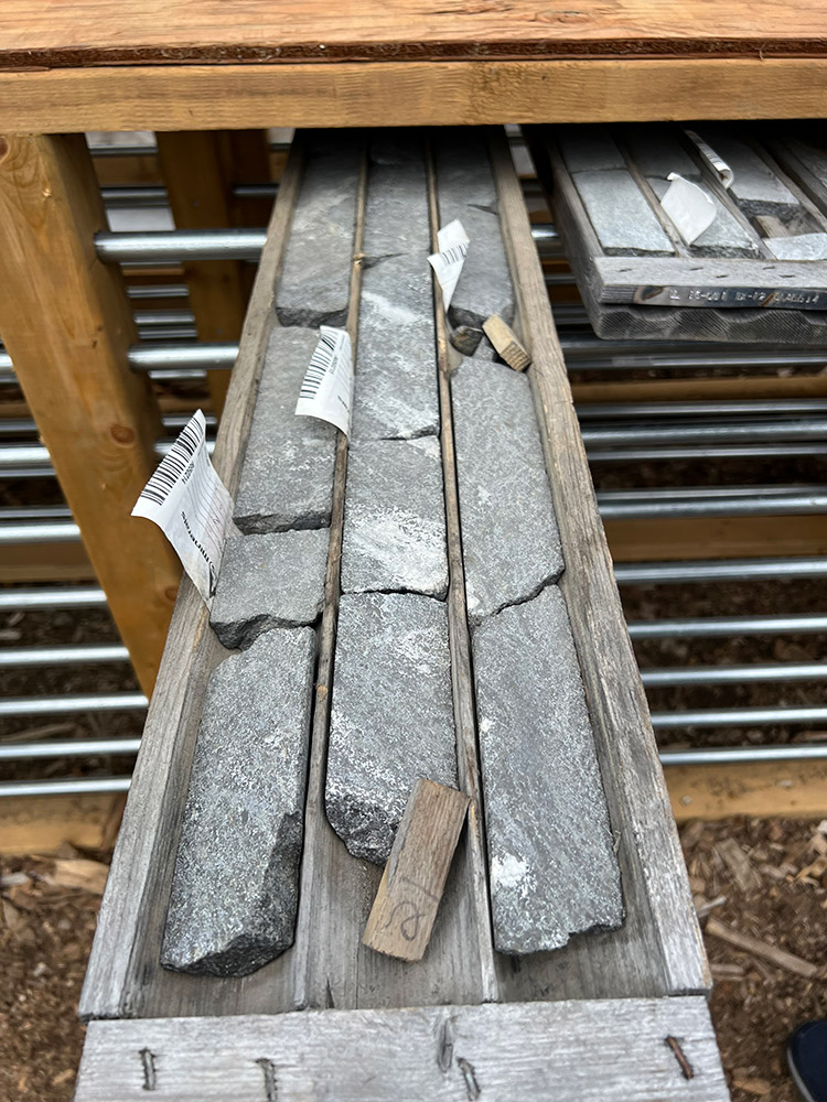
La Loutre
La Loutre is classified as the 7th biggest graphite deposit in the world by Mining.com and Mining Intelligence.
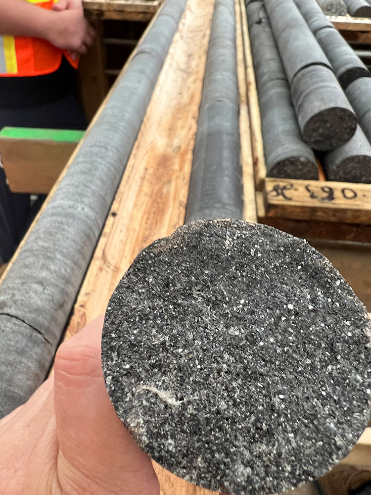
The Property is underlain by rocks from the Grenville Province of the Precambrian Canadian Shield. The Grenville was formed under conditions that were very favorable for the development of coarse-grained, flake-type graphite mineralization from organic-rich material during high-temperature metamorphism.
Lomiko Metals published an updated Mineral Resource Estimate (MRE) in a NI 43-101 Technical Report and Mineral Resource Estimate Update for the La Loutre Project, Quebec, Canada, prepared by InnovExplo on May 11th, 2023, which estimated 64.7 million tonnes of Indicated Mineral Resources averaging 4.59% Cg per tonne for 3.0 million tonnes of graphite, a tonnage increase of 184%. Indicated Mineral Resources increased by 41.5 million tonnes as a result of the 2022 drilling campaign, from 17.5 million tonnes in 2021 MRE with additional Mineral resources reported down-dip and within marble units resulted in the addition of 17.5 million tonnes of Inferred Mineral Resources averaging 3.51% Cg per tonne for 0.65 million tonnes of contained graphite; and the additional 13,107 metres of infill drilling in 79 holes completed in 2022 combined with the refinement of the deposit and structural models contributed to the addition of most of the Inferred Mineral Resources to the Indicated Mineral Resource category, relative to the 2021 Mineral Resource Estimate. The MRE assumes a US$1,098.07 per tonne graphite price and a cut-off grade of 1.50% Cg (graphitic carbon).
The independent and qualified persons for the mineral resource estimate, as defined by NI 43 101, are Marina Iund, P.Geo. (InnovExplo Inc.), Martin Perron, P.Eng. (InnovExplo Inc.)., Simon Boudreau, P.Eng. (InnovExplo Inc.). and Pierre Roy, P.Eng. (Soutex Inc.). The effective date of the estimate is May 11, 2023.
Lomiko Metals Graphite Portfolio
The company’s graphite portfolio in southern Quebec comprises 400 claims in total, covering 7 early-stage projects spanning 22,845 hectares. These new claims lie within a 100 km radius of the Company’s flagship La Loutre graphite project and 28 claims are directly contiguous to La Loutre, with the Company claim package now covering 4,528 hectares. The highest graphite grades are commonly associated with rock contacts between marble and paragneiss or quartzite which is the host rock present in the Grenville Province and at La Loutre. Large, disseminated flake graphite mineralization occurs at a number of places in the Grenville Province metamorphic belt, located in Canada’s Quebec and southeastern Ontario jurisdictions, and the conglomeration of this mineralization in close proximity in the region presents opportunities in the future for responsible and low impact mining or quarry activities that are unique to this region.
The company also holds interest in seven early stage projects in southern Quebec including Ruisseau, Tremblant, Meloche, Boyd, Dieppe, North Low and Carmin covering 328 claims in total on 7 early-stage projects covering 18,622 hectares in the Laurentian region of Quebec and within KZA territory.

Ruisseau
Highlights from the 2024 exploration season
During 2024 work program Lomiko Metals encountered up to 27.9% graphite at its Laurentides early-stage projects, including the discovery of four new zones at the Ruisseau project spanning over 3 kilometres long.
Highlights from the 2025 exploration season
The spring field program, which confirmed the continuity of the two western zones and revealed extended mineralization through our sampling efforts. Notably, one of the western zones expanded significantly—from 1,480 metres in 2024 to approximately 3,850 metres. These promising results have led to development of a plan for further exploration, including a maiden drill program targeting the two western zones. The plan outlines 38hole with 18 holes in the Rune zone and 20 in La Roche, totaling an initial 2,500 metres
In 2023 and 2024, a total of 35 samples were collected along the Rune TDEM trend, with seven samples returning 15 to 20 per cent graphitic carbon (% Cg) and fifteen samples returning >20% Cg up to a maximum of 27.90% Cg along a 1,450-metre strike length. At La Roche, a total of 23 samples were collected along a 1,480-metre strike length with six samples returning 15 to 20% Cg and six returning >20% Cg up to a maximum of 24.70% Cg.

Yellow Fox
A two-phase soil sampling program in 2025, initially targeting the Mount Peyton monzogranite, prospective for critical metals (Sb, Pb, Zn, Au, Ag), resulted in the identification of several highly prospective critical metal soil anomalies with associated pathfinder elements, which exhibited a strong correlation to the Yellow-Fox showing. In addition, two REEs (Rare Earth Elements), Lanthanum (La) and Cerium (Ce) were also a part of the ICP package with assays indicating several highly prospective anomalies with Ce values up to 2,510 (See Table 1) parts per million (ppm) and La values up to 414 ppm. The largest anomaly (Anomaly#1) is approximately 500m in width and a minimum of 1300m in length (See Figure 1). The second anomaly (Anomaly#2), which is located immediately east of Anomaly #1, is approximately 175m in width and a minimum of 1000m in length. These new anomalies are trending roughly north (N)-northeast (NE), similar to that of the highly prospective regional structures, which also trend N-NE. Outcrops are sparse, especially on the eastern portion of the project. Many boulder trains are present, illustrating variable grain sizes and degrees of alteration, a further indication of a potential prospective host rock for both REE and critical metals mineralized systems.

Based on the promising REE results from the original ICP assays, seven samples were selected for additional analysis to determine if any additional REEs are present. A specific REE assay package was utilized.
Assay results for these seven soil samples indicated highly anomalous assays for both light rare earth elements (LREE) and heavy rare earth elements (HREE) (See Table 1). These new soil results indicate a strongly potentially geologically significant REE soil anomaly, highlighting a fertile monzogranite. This anomaly exhibits strong LREE enrichment (La-Ce-Pr-Nd-Eu) accompanied by highly elevated HREE (Dy-Tb-Y), potentially indicating a mixed LREE and HREE mineralized system. TREE (Total Rare Earth Element) values range from 1,683 ppm to 5,176 ppm. Initial soil samples in this range for TREE are highly promising and warrant follow-up exploration work. Of particular interest in these results is the highly anomalous LREEs Neodymium (Nd) and Praseodymium (Pr), which are instrumental in the manufacturing of magnets. Elevated dysprosium (Dy) is also present, which is a HREE and enables magnets to perform at high temperatures. Thorium, which is often seen as a pathfinder for REE, is also present in elevated numbers.
Highlights:
- 7 soil samples were re-run for the Rare Earth Elements (“REE”) specific test package for assays outlining the cerium anomaly and to check for other REE elements, including neodymium, praseodymium, gallium, etc.
- Soil samples assaying from 1697ppm to 5176 ppm or (0.52%) REEs.
- NEW potential rare earth discovery.
- Highly anomalous LREEs Neodymium (Nd) from 186 to 890ppm and Praseodymium (Pr) at 46-192ppm, which are instrumental in the manufacturing of magnets.
- Elevated dysprosium (Dy) at 36 – 191ppm.
- Identification of multiple highly anomalous REE soil anomalies (See Figure 1).
- REEs hosted within Mount Peyton monzogranite.
- REE anomalies roughly parallel to previously outlined Sb-Zn-Pb-Ag critical metal anomalies.
Strategic growth in the green technology and defense sectors will contribute to increased demand for REEs. The primary drivers for the increased use of REEs include wind turbines, electric vehicles, defense and aerospace, as well as advanced electronics.
Last summer saw the identification of several expansive, untested critical metal soil anomalies (Sb-Pb-Zn-Ag-Au) up to 1,200m in length, which also included the discovery of highly anomalous REE values (La, Ce). These REE results, in conjunction with the seven samples discussed in this release, further indicate a second type of highly prospective, untested targets with highly anomalous LREE and HREE assays on top of the more common Ce and La.
Phase I & II soil sampling has proven to be highly successful in locating and delineating potential mineralized structures on the Yellow Fox project, especially given the lack of outcrop. The next stages or work will include line cutting and ground geophysics to better define the orientation and location of high-priority targets, followed by surface trenching and geological mapping.
Yellow Fox antimony and REE prospect exploration – future steps
- Next work phase will include additional re-assaying of previously collected soil samples for REEs, as well as infill soil sampling between lines to better define the true extent and orientation of these REEs anomalies
- Ground geophysics followed by surface trenching
- Line cutting, drilling, ground geophysics, and surface trenching permits have been received.
- Surface stripping will be followed by channel sampling and geological mapping
Location Details
The Yellow Fox Property is located approximately 10 km southwest of the Town of Glenwood NL, and south of the Trans-Canada Highway. The property is located within NTS map sheets 02D/14 and 15, offering excellent access along several logging and skidder roads that originate from Glenwood. The main Yellow Fox showing is located in the central part of License 027536M, 5km from the western end of Gander Lake. The property is centered at approximately UTM (NAD 27) grid coordinates 5,419,400m North and 645,300m East.
Geologically, Yellow Fox exhibits similar traits to those of Beaver Brook, with cross-cutting structural zones that show intense carbonate alteration with sulphide-bearing stringers to veins of stibnite and arsenopyrite with similar high-grade tenors of antimony, gold, lead, zinc, and silver. Arsenopyrite is also present in both locations. Two prominent fracture vein sets are present, one being the muscovite-pyrite-rutile veins trending 356 degrees and the second stibnite-quartz-arsenopyrite being the most abundant and trending 025 degrees. Both of these vein sets are similar to those of the past-producing Beaver Brook antimony Mine, and both vein sets trend in a N to NE direction, which is consistent with the prospective regional structures. Yellow Fox has never been explored for REEs. Importantly, the project is underlain by the Mount Peyton intrusion, which potentially appears to be a fertile environment for the emplacement of REEs. Initial interpretation indicates REEs are located near the intrusive contact with neighboring volcanics and sediments.
The surface soil and grab samples described in this news release are selective by nature and are unlikely to represent average grades on the property.
Please note that the results on an adjacent or nearby property (Beaver Brook) are not necessarily what can be expected on the Yellow Fox project, and that the results of surface or grab samples, by their nature, are selective, and that the assay results may not be indicative of underlying mineralization.
Qualified Person
The technical content presented in this press release was reviewed and approved by Gordana Slepcev, P.Eng., who is the CEO & President of Lomiko Metals and acts as the “Qualified Person” as that term is defined under National Instrument 43-101, Standards of Disclosure for Mineral Projects. Also, Wayne Reid, P.Geo, and director for the Corporation (MEK) and a qualified person as defined in National Instrument 43-101, has reviewed and approved the disclosure of the exploration information in this news release.
All 851 initial soil samples from this past summer’s programs were dried and then sent to Eastern Analytical Ltd., located in Springdale, Newfoundland, Canada. Samples are analyzed by the ICP34 method that delivers a 34-element package and analyzed by the ICP-OES analytical technique with blanks and standards inserted every 20-25 samples. The 7 samples in this press release were sent to Bureau Veritas, located in Vancouver, British Columbia, Canada. Samples are analyzed by ICP-OES utilizing a multi-acid digestion analytical technique. No standards or blanks were added to this batch of 7 samples.


Land Acknowledgement
The land and projects where we operate are located within the traditional land of the Algonquin Anishnaabeg and Cree Eeyou Istchee Peoples.
Our vision is to embrace Indigenous people and Indigenous values within our projects in order to develop a sustainable approach on our path to critical minerals development, while honouring the lives, memories, and hopes of all seven generations close.
The La Loutre graphite project site is located within the Kitigan Zibi Anishinabeg (KZA) First Nation’s territory. The KZA First Nation is part of the Algonquin Nation and the KZA traditional territory is situated within the Outaouais and Laurentides regions.
The Bourier lithium project site is located south-east of the Eeyou Istchee James Bay territory in Quebec, near Nemaska Lithium and Critical Elements.