May 2025 Field Program
The 2025 work program consisted of prospecting and sampling over a 10-day period with the aid of a Beep-Mat. A total of 39 rock samples, including three QAQC samples, were collected. The samples showed strong results with 29 of 36 samples returning greater than 1.0% Cg as follows:
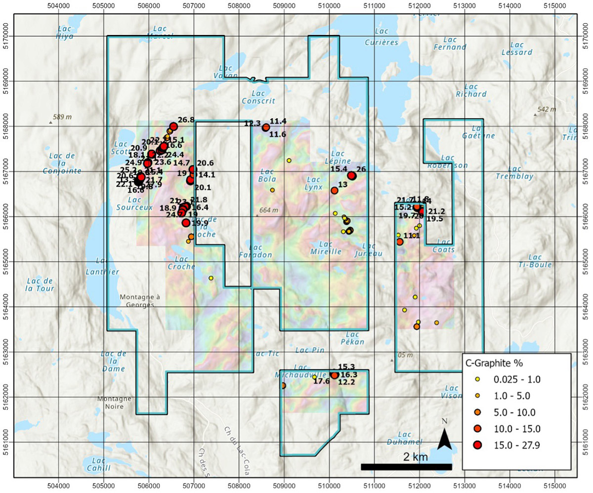
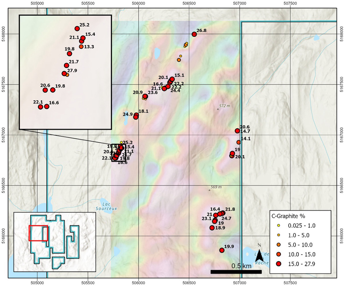
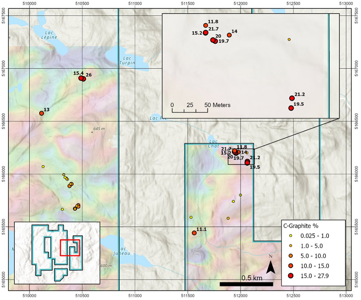
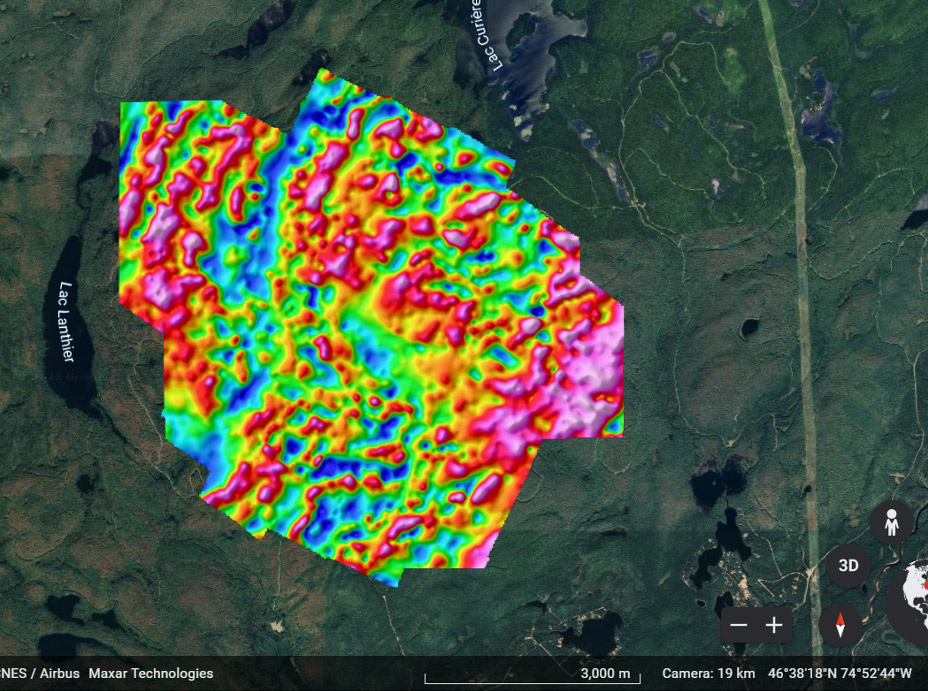
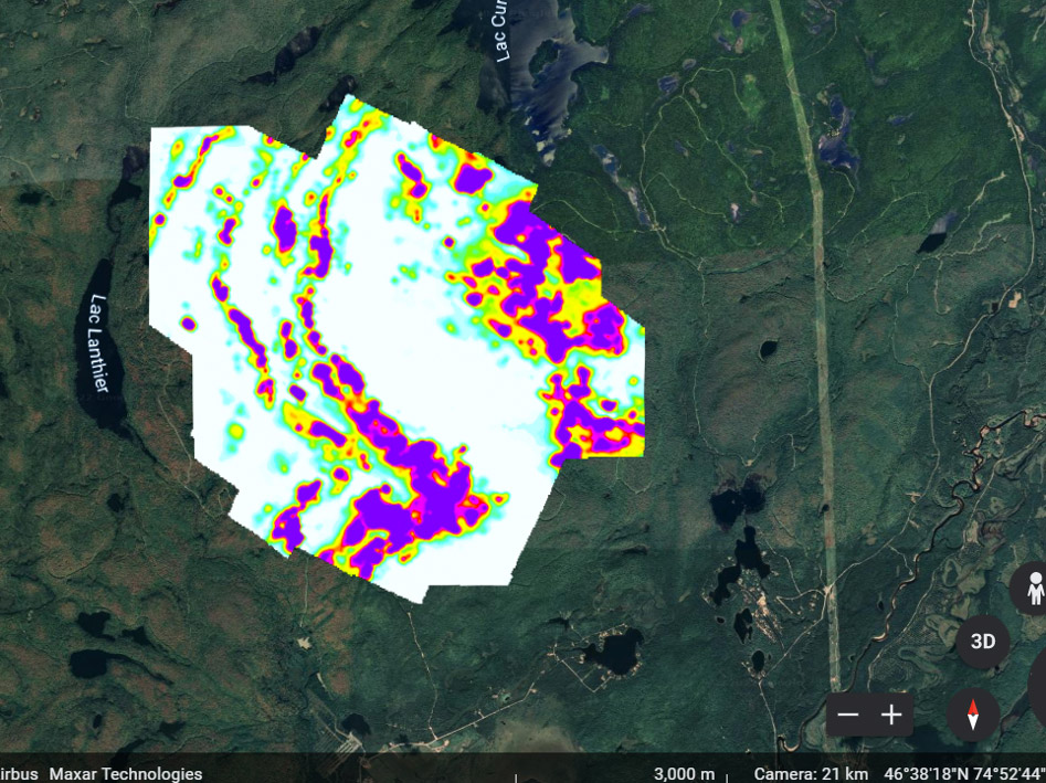
The northeast-trending Rune zone has been delineated by prospecting and sampling along an airborne TDEM trend over a length of 1,450 metres. It remains open to the northeast and southwest beyond the limits of the 2022 Airborne. The Beep-Mat detected conductivity over surface widths up to 25 metres in places across the zone. Sampling in 2025 at the southern limit of the airborne geophysical coverage returned strong graphite results up to a maximum of 27.5% Cg. Prospecting and sampling on the south projection of the Rune zone outside the limits of the 2022 airborne geophysical survey returned two widely spaced, strong values of 6.01 and 18.00% Cg from float samples.
In addition, the 2025 sampling along the southern extension of the La Roche TDEM trend was incredibly successful with numerous moderate to high grade results up to a maximum of 27.5% Cg. The known strike length of the La Roche graphite zone on the Property was extended from 1,480 metres in 2024 to approximately 3,850 metres. The Beep-Mat detected high conductivity over surface widths up to 50 metres in places. The La Roche zone is approximately 450 metres east of and runs parallel to the Rune zone. La Roche zone coincides with an airborne TDEM trend that extends for its entire length within the Property and that likely continues beyond the limits of the Property.
The graphite mineralization at both Rune and La Roche is commonly found in bands within paragneiss and consists of very coarse-grained graphite flakes. It is usually accompanied by biotite and minor sulphides and is typically quite rusty. The apparent thickness of individual bands can be inferred by strong conductivity readings from the Beep-Mat, with an average width of 5 to 10 metres and lengths of 100 to 200 metres.
Structurally, the Rune and La Roche zones appear to be on opposite limbs of a north – to northeast-trending synform. Both zones show moderate to shallow dips that are on average 50° from horizontal. Typically, graphite bands are best exposed along the west margin of the Rune TDEM trend and dip east, whereas graphite bands are found along the east margin of the La Roche TDEM trend and dip west.
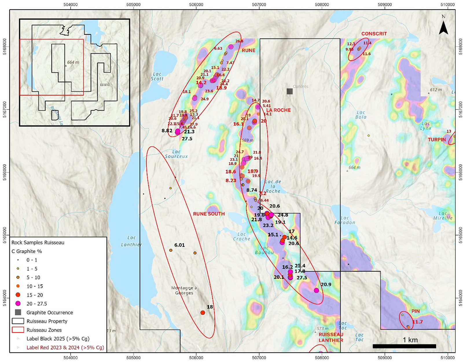
Figure 1: Compilation of rock sampling results obtained during Early Off-Time (TDEM) sampling.
Drill Program Proposed
A total of five primary and four secondary targets at Rune and six primary and four secondary targets at La Roche have been selected for drill testing based on the 2022 airborne geophysical survey and the strong graphite values obtained from the 2023, 2024 and 2025 prospecting and sampling programs. The Company intends to proceed with a 2,500-metre drill program that will test the Priority 1 drill targets at Rune and La Roche.
Permitting has been initiated with the expectation that drilling can begin in early November 2025.
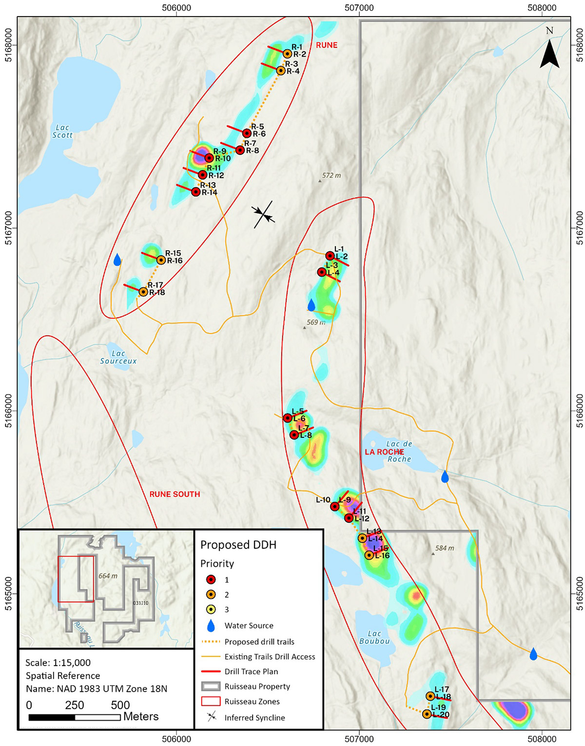
Figure 2: Proposed drill targets for the Rune and La Roche zones identified using Late Off-Time (TDEM) data.
QAQC and Analytical Procedures
All rock sample locations were recorded with Android rugged smart phones running Q-Field data collection software in map datum UTM WGS84 Zone 18N. The Rock samples were photographed and placed in plastic sample bags with sample numbers written on the bags in indelible ink. A plastic, waterproof tag was left at the sample site. The samples were sealed in a rice bag with a zip tie and delivered by Breakaway personnel to Activation Laboratories Ltd. (“Actlabs”) in Val d’Or, Quebec. Two certified reference material standards and on blank were included with the 36 samples collected in 2025. In Val d’Or, the samples were crushed to 80% passing 2mm and then riffle split to a 250g sub-sample that was pulverized to 95% passing 105μm (Actlabs Code RX1). The sample pulps were then analyzed for graphitic carbon “Cg” by mild hydrochloric acid digestion followed by combustion in an infrared induction furnace (Actlabs Code 8Cg). Actlabs is accredited under ISO 9001:2015 registration and is independent of the Company.
Qualified Person
The technical content presented in this press release was reviewed by Mark Fekete, P.Geo., who acts as an independent consultant to the Company as the “Qualified Person” as that term is defined under National Instrument 43-101, Standards of Disclosure for Mineral Projects.