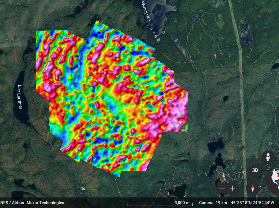
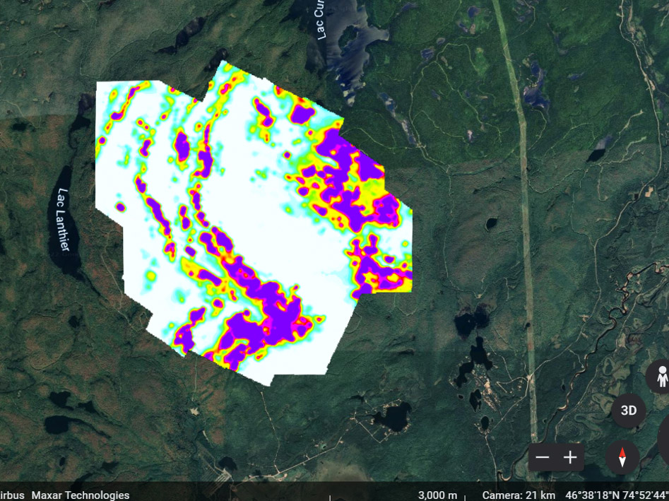
Secured large parcel of open ground within favourable paragneiss and regional fold structures.

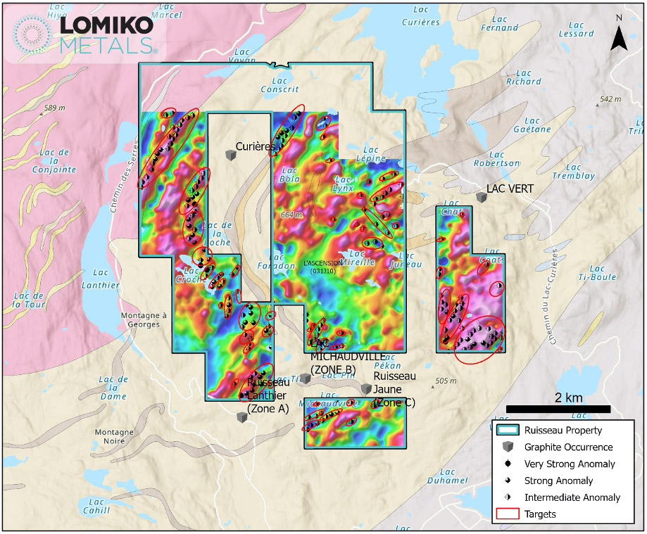
Location: 50 km ENE of Mont-Laurier. Excellent access. The land package is secured around four major showings

  • Ruisseau Lanthier (Zone A)
  • Lac Michaudville (Zone B)
  • Ruisseau Jaune (Zone C)
  • Lacs Verts

# of claims: 47

The 246-line-km survey flown over the 47-claim Ruisseau project located 50 km ENE of Mont-Laurier identified 538 TDEM point anomalies with 204 having an intermediate to very strong conductive response. Eleven linear TDEM trends and three spot anomalies show strong correlation with magnetic trends and are considered as prospective targets for graphite-sulphide mineralization. Ten other TDEM trends are associated with MAG lows or do not show any clear correlation to magnetic data. Graphite hosted within non-magnetic marble rocks may be the source of TDEM responses of this sort.

Lomiko - Ruisseau Property

Ruisseau Lanthier (Zone A)

Work history: In 1989, Graphicor Resources – Staking, geophysical survey. In 1989-1990, Graphicor Resources – Drilling. In 2013, Caribou King – Prospecting, drilling. In 2013, Vision Exploration – Geophysical survey.

Holder: Unimera Holding Public (2018)

Lithology: Graphite mineralization is associated primarily with marble. Mineralization is also found in paragneiss and quartzite (L’Ascension Supracrustal Suite)(GM 69035).

Morphology: This graphite mineralized zone corresponds to a strip of marble nearly 2 m wide, oriented NW70/60. Graphite mineralization occurs as flakes evenly distributed within the marble. Graphite mineralization is also found in nodules of 2 to 10 mm in marble (GM 69035).

Genesis: Successive metamorphism of sedimentary strata containing organic matter.

Mineralization: Grade: 10.14% Cg (graphitic carbon) over 6.0 m (hole T89-13); 12.46% Cg over 3.0m (90-20 sounding); 15.88% Cg over 2.14 m (hole T89-04); 19.49% Cg and 19.19 Cg (surface sample T-004 and T-005-A) (GM-51068). This graphite mineralized zone corresponds to a band of carbonate metasedimentary rocks (marble) locally containing up to 20% disseminated crystalline graphite. Graphite mineralization occurs as flakes of 0.5 to 2 mm. Graphite occurs in the foliation planes of the rock. There are sulphides, including pyrite and pyrrhotite, associated with graphite (GM 69035).

Lac Michaudville (Zone B)

History of work: In 1991, Graphicor Resources – Geological cartography.

Holder: Unimera Holding Public (2018)

Lithology: Graphite is found within schistose gneissic bands.
: This mineralized zone of graphite is found inside bands of gneiss whose thicknesses are metric. The strength of the graphitic horizons is tightly controlled by the structure, ie a system of isoclinal folds P1 at N 232/24 degrees taken up by P2 at N 270/30 degrees.

Typology: Genesis: Successive metamorphism of sedimentary strata containing organic matter.

Mineralization: Grade: 15.53% Cg, 12.60% Cg, 11.40% Cg and 8.70% Cg (surface sample T-017, T-018, T-015 and T-021; GM -51068). Graphite is generally found in flakes from 0.5 mm to 5 mm in diameter. Flakes one centimeter in diameter

Ruisseau Jaune (Zone C)

Discovery: Mineralized zone discovered in 1989.

Work history: In 1989, —— Geological survey.

Holder: Unimera Holding Public (2018)

Lithology: The host rock is a schistose paragneiss.

Morphology: This graphitic band was observed over a hundred meters in length. These bands are part of a P1 isoclinal system oriented 77° NW. Measured dips range from sub-horizontal to 63 degrees.

Typology: Genesis: successive metamorphism of sedimentary strata containing organic matter during Grenvillian orogenies.

Mineralization: Grade: 12.17% Cg (graphitic carbon) (example T-023) and 11.86 Cg (T-024): surface samples. Drilling samples assayed 9.86% Cg over 46.75 m (drilling 90-44); 10.48% Cg over 5.20 m (drilling 90-43); 12.17% Cg and 11.86% Cg; GM-51068. The graphite is disseminated and is generally found in flakes of 0.5 mm to 5 mm in diameter. Flakes one centimeter in diameter were noted. Visually, the percentage of graphite varies from 12 to 20%.

Lacs Verts

Mineralized zone located 500 m south of the Petits Lacs Verts (Range VII; Lots 53-54).

Year discovered: 1989

Discovery: Mineralized zone with outcrop discovered in 1989 by geological mapping. Work history: In 1990, Res. Graphicor – Geological survey, sampling, drilling and analysis.

Holder: Unimera Holding Public (2018)
How – lithology: Lithologies: A – Marble; B – Biotite-sillimanite pargneiss.

Minerals: Graphite, biotite, sillimanite, calcite, quartz

Morphology: The shape of the mineralized zone is tabular and conforms to the orientation of the different stratigraphic units, trending East to ESE with slight dips towards the SSW.

Typology: Genesis: Successive metamorphism of sedimentary strata containing organic matter during Grenvillian orogenies.

Mineralization: Grades: Four grab samples from two mineralized discoveries, respectively assayed 20.73% graphitic carbon Cg (example no.42409), 21.25% Cg (example no.42411), 23.0% Cg (sample no.42424) and 15.09% Cg (sample no.42425). A hole (V90-06), drilled 700 m to the WNW, intersected 9.25% Cg over 3.35 m in graphitic rock, sometimes carbonated (marble). High graphite grades (15-20%) are contained in a crystalline marble unit. Grades below 10% Cg were also obtained in other metasedimentary units. Schistous gneiss with biotite and sillimanite revealed grades of the order of 4 to 5% Cg. The graphite is disseminated and comes in the form of flakes whose size varies between 0.5 and 1.5 mm.

2024 Results

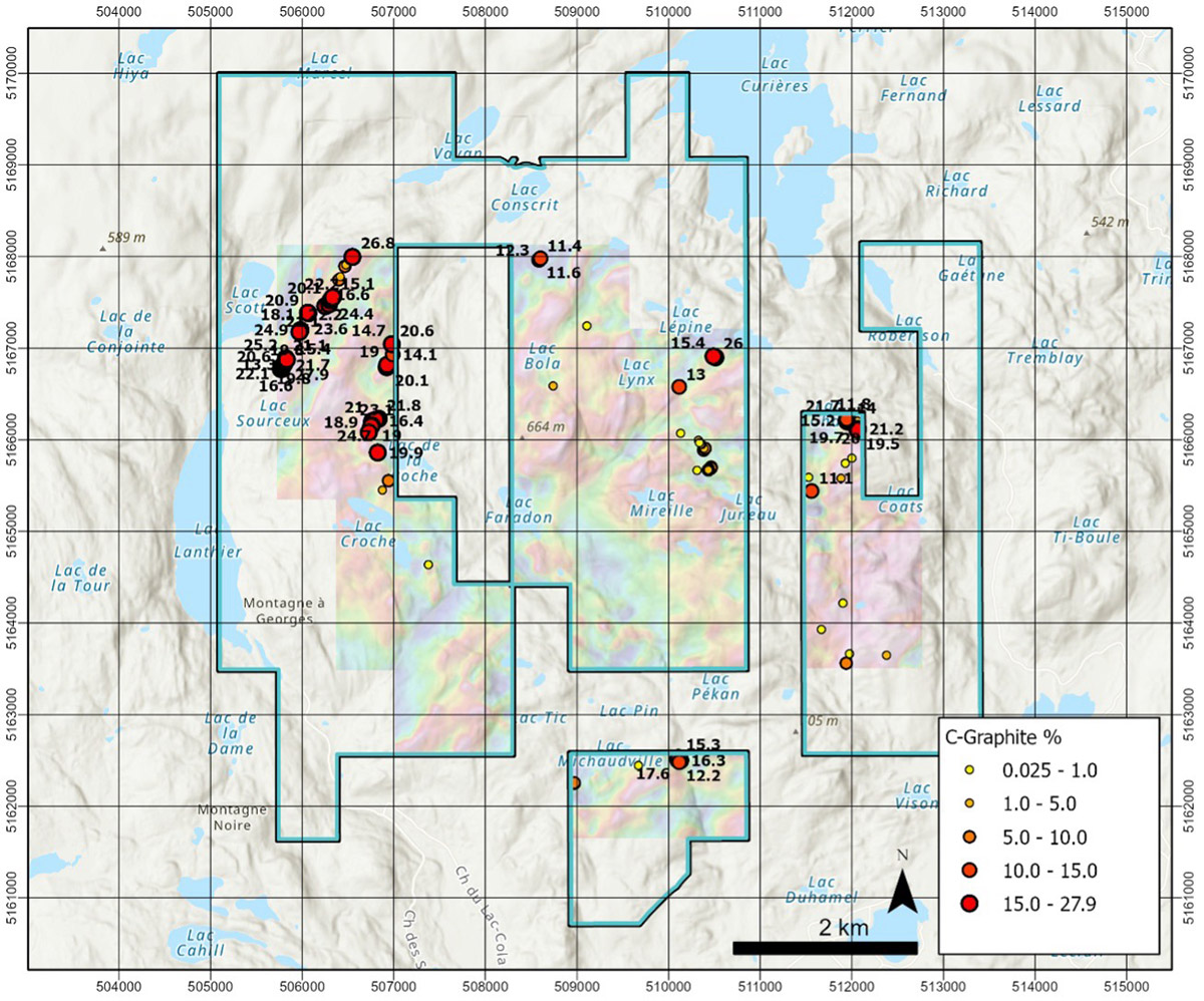
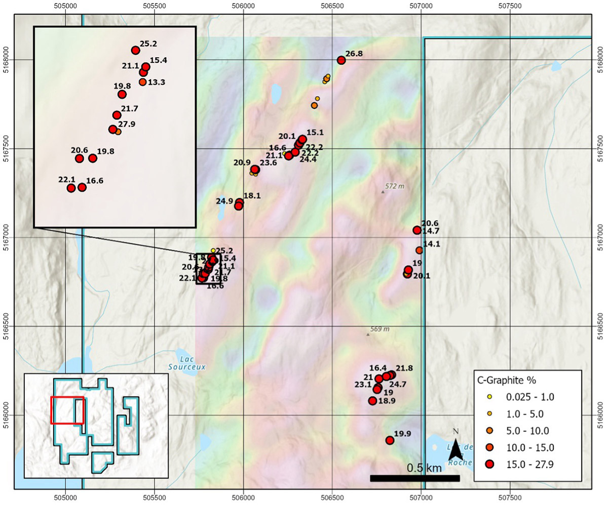
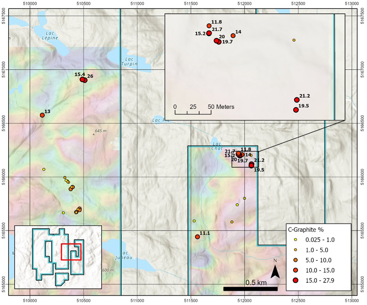
From a total of 107 selected grab samples collected on the Ruisseau property in 2024, 24 samples returned results greater than 20% Cg, 55 samples returned results greater than 10% Cg, 71 samples returned results greater than 5% Cg and 92 samples returned results greater than 1% Cg.  Four distinct linear high grade graphite zones were encountered including:

  • the “Northwestern” zone exposed over a horizontal distance of 1,500m with maximum values up to 27.9% Cg;
  • the “Western” zone exposed over a horizontal distance of 1,300m with maximum values up to 24.7% Cg;
  • the “Eastern” zone exposed over a horizontal distance of 200m with maximum values up to 21.7% Cg; and
  • the “Southern” zone exposed over 75m exposed with maximum values up to 17.6% Cg.

All zones trend slightly northeast except for the Southern zone, which trends east.  All zones are new discoveries except for the Southern zone which was first encountered by the Company in 2023.  Although discontinuous, it appears that the Southern zone may be up to 500m long on Ruisseau and may trend off the property both to the east and west.  All the Ruisseau zones appear to be several 10s of meters wide on the surface, but true widths are uncertain due to extensive overburden cover. Refer to figure 1, 1a and 1b for details.

Figure 1: Ruisseau Results

Figure 1: Ruisseau Results

Figure 1a: Ruisseau West Results

Figure 1a: Ruisseau West Results

Figure 1b: Ruisseau East Results

Figure 1b: Ruisseau East Results

May 2025 Field Program

The 2025 work program consisted of prospecting and sampling over a 10-day period with the aid of a Beep-Mat. A total of 39 rock samples, including three QAQC samples, were collected. The samples showed strong results with 29 of 36 samples returning greater than 1.0% Cg as follows:

#

Category

Range

1

Below detection

< 0.05% Cg

6

Below the Anomalous threshold

< 1.0% Cg

5

Anomalous

1.0 to < 5.0% Cg

4

Low grade

5.0 to <10.0% Cg

8

Moderate grade

10.0 to <20.0% Cg

12

High grade

20.0% Cg

36

Total


The northeast-trending Rune zone has been delineated by prospecting and sampling along an airborne TDEM trend over a length of 1,450 metres. It remains open to the northeast and southwest beyond the limits of the 2022 Airborne. The Beep-Mat detected conductivity over surface widths up to 25 metres in places across the zone. Sampling in 2025 at the southern limit of the airborne geophysical coverage returned strong graphite results up to a maximum of 27.5% Cg. Prospecting and sampling on the south projection of the Rune zone outside the limits of the 2022 airborne geophysical survey returned two widely spaced, strong values of 6.01 and 18.00% Cg from float samples.

In addition, the 2025 sampling along the southern extension of the La Roche TDEM trend was incredibly successful with numerous moderate to high grade results up to a maximum of 27.5% Cg. The known strike length of the La Roche graphite zone on the Property was extended from 1,480 metres in 2024 to approximately 3,850 metres. The Beep-Mat detected high conductivity over surface widths up to 50 metres in places. The La Roche zone is approximately 450 metres east of and runs parallel to the Rune zone. La Roche zone coincides with an airborne TDEM trend that extends for its entire length within the Property and that likely continues beyond the limits of the Property.

The graphite mineralization at both Rune and La Roche is commonly found in bands within paragneiss and consists of very coarse-grained graphite flakes. It is usually accompanied by biotite and minor sulphides and is typically quite rusty. The apparent thickness of individual bands can be inferred by strong conductivity readings from the Beep-Mat, with an average width of 5 to 10 metres and lengths of 100 to 200 metres.

Structurally, the Rune and La Roche zones appear to be on opposite limbs of a north – to northeast-trending synform. Both zones show moderate to shallow dips that are on average 50° from horizontal. Typically, graphite bands are best exposed along the west margin of the Rune TDEM trend and dip east, whereas graphite bands are found along the east margin of the La Roche TDEM trend and dip west.
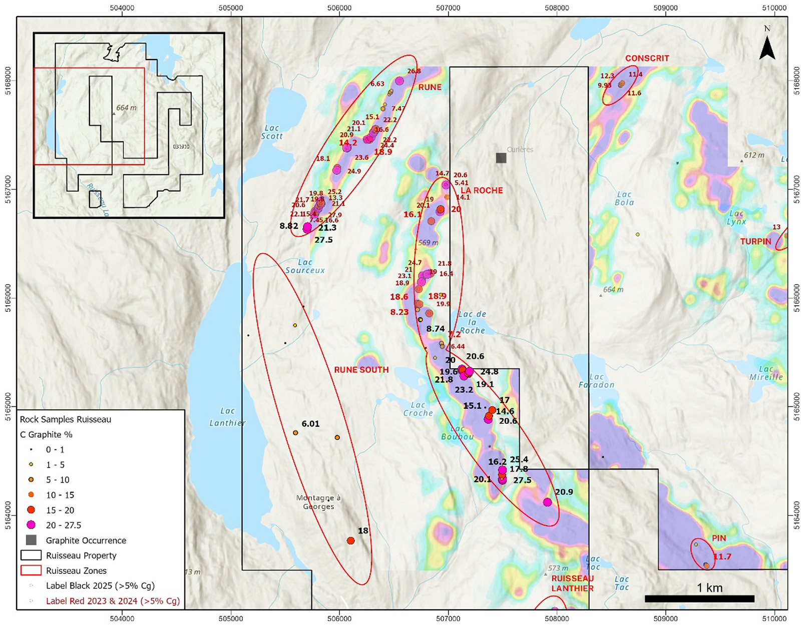
Figure 1 : Compilation des résultats de l’échantillonnage de roches obtenues lors de l’échantillonnage à temps de réception précoce (Early Off Time) TDEM
Figure 1: Compilation of rock sampling results obtained during Early Off-Time (TDEM) sampling.


Drill Program Proposed

A total of five primary and four secondary targets at Rune and six primary and four secondary targets at La Roche have been selected for drill testing based on the 2022 airborne geophysical survey and the strong graphite values obtained from the 2023, 2024 and 2025 prospecting and sampling programs. The Company intends to proceed with a 2,500-metre drill program that will test the Priority 1 drill targets at Rune and La Roche.

Permitting has been initiated with the expectation that drilling can begin in early November 2025.
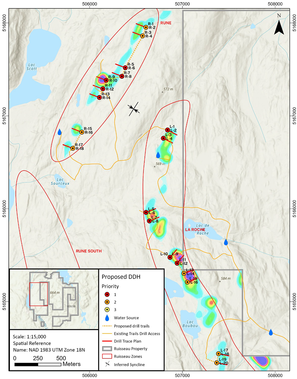
Figure 2 : Cibles de forage proposées pour les zones de Rune et de La Roche déterminées avec les données de temps de réception tardif (Late Off Time), TDEM
Figure 2: Proposed drill targets for the Rune and La Roche zones identified using Late Off-Time (TDEM) data.


QAQC and Analytical Procedures

All rock sample locations were recorded with Android rugged smart phones running Q-Field data collection software in map datum UTM WGS84 Zone 18N. The Rock samples were photographed and placed in plastic sample bags with sample numbers written on the bags in indelible ink. A plastic, waterproof tag was left at the sample site. The samples were sealed in a rice bag with a zip tie and delivered by Breakaway personnel to Activation Laboratories Ltd. (“Actlabs”) in Val d’Or, Quebec. Two certified reference material standards and on blank were included with the 36 samples collected in 2025. In Val d’Or, the samples were crushed to 80% passing 2mm and then riffle split to a 250g sub-sample that was pulverized to 95% passing 105μm (Actlabs Code RX1). The sample pulps were then analyzed for graphitic carbon “Cg” by mild hydrochloric acid digestion followed by combustion in an infrared induction furnace (Actlabs Code 8Cg). Actlabs is accredited under ISO 9001:2015 registration and is independent of the Company.

Qualified Person

The technical content presented in this press release was reviewed by Mark Fekete, P.Geo., who acts as an independent consultant to the Company as the “Qualified Person” as that term is defined under National Instrument 43-101, Standards of Disclosure for Mineral Projects.